Yana & Marty Davis Map Collection

at the Museum of the Big Bend
dingbat About the Collection

Browse Maps by:

Skip to content
  • Date
    • 1525(1)
    • 1548(1)
    • 1550(1)
    • 1561(1)
    • 1584(1)
    • 1596(1)
    • 1597(1)
    • 1601(1)
    • 1601(1)
    • 1630(1)
    • 1640(1)
    • 1641(1)
    • 1662(1)
    • 1688(1)
    • 1701(1)
    • 1703(1)
    • 1705(1)
    • 1708(1)
    • 1718(1)
    • 1735(1)
    • 1753(1)
    • 1756(2)
    • 1757(1)
    • 1785(1)
    • 1791(1)
    • 1804(1)
    • 1807(1)
    • 1808(1)
    • 1809(1)
    • 1812(2)
    • 1816(1)
    • 1817(1)
    • 1821(1)
    • 1822(1)
    • 1824(1)
    • 1825(1)
    • 1826(1)
    • 1827(2)
    • 1828(1)
    • 1829(1)
    • 1832(1)
    • 1835(3)
    • 1835(1)
    • 1836(1)
    • 1837(1)
    • 1839(1)
    • 1840(1)
    • 1844(2)
    • 1845(2)
    • 1846(1)
    • 1847(1)
    • 1848(1)
    • 1849(4)
    • 1850(1)
    • 1851(1)
    • 1853(1)
    • 1857(3)
    • 1863(1)
    • 1864(1)
    • 1879(1)
    • 1886(2)
    • 1889(1)
    • 1890(1)
    • 1892(1)
    • 1905(1)
    • 1910(1)
    • 1911(1)
    • 1914(1)
    • 1916(1)
    • 1918(1)
    • 1920(1)
    • 1928(1)
    • 1934(1)
  • Geography
    • America(31)
    • City(2)
    • Discovery(2)
    • Mexico(13)
    • Misc(1)
    • Oklahoma(1)
    • Texas(23)
    • United States(12)
  • Theme
    • Astronomical(1)
    • Bird's-eye view(1)
    • Commemorative(1)
    • Commercial(5)
    • Discovery(17)
    • Educational(1)
    • Exploration(12)
    • Geological(3)
    • Military(9)
    • Political(28)
    • Settlement(2)
    • Transportation(4)
Search Maps

Date

  • 1525(1)
  • 1548(1)
  • 1550(1)
  • 1561(1)
  • 1584(1)
  • 1596(1)
  • 1597(1)
  • 1601(1)
  • 1601(1)
  • 1630(1)
  • 1640(1)
  • 1641(1)
  • 1662(1)
  • 1688(1)
  • 1701(1)
  • 1703(1)
  • 1705(1)
  • 1708(1)
  • 1718(1)
  • 1735(1)
  • 1753(1)
  • 1756(2)
  • 1757(1)
  • 1785(1)
  • 1791(1)
  • 1804(1)
  • 1807(1)
  • 1808(1)
  • 1809(1)
  • 1812(2)
  • 1816(1)
  • 1817(1)
  • 1821(1)
  • 1822(1)
  • 1824(1)
  • 1825(1)
  • 1826(1)
  • 1827(2)
  • 1828(1)
  • 1829(1)
  • 1832(1)
  • 1835(3)
  • 1835(1)
  • 1836(1)
  • 1837(1)
  • 1839(1)
  • 1840(1)
  • 1844(2)
  • 1845(2)
  • 1846(1)
  • 1847(1)
  • 1848(1)
  • 1849(4)
  • 1850(1)
  • 1851(1)
  • 1853(1)
  • 1857(3)
  • 1863(1)
  • 1864(1)
  • 1879(1)
  • 1886(2)
  • 1889(1)
  • 1890(1)
  • 1892(1)
  • 1905(1)
  • 1910(1)
  • 1911(1)
  • 1914(1)
  • 1916(1)
  • 1918(1)
  • 1920(1)
  • 1928(1)
  • 1934(1)

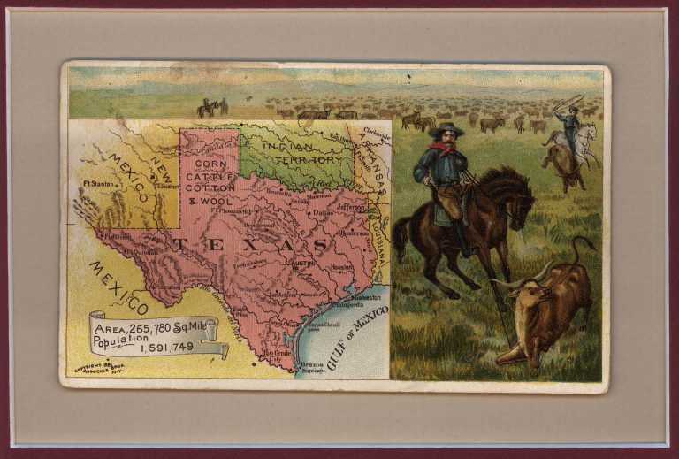
Date: 1889 (1 Map with Images)

Show All Maps
1

1889: Postcard Map of Texas, New Mexico, and Indian Territory

Cartography:
Arbuckle Brothers Coffee

Pittsburgh grocers John and Charles Arbuckle patented a method for roasting coffee involving coating beans with a glaze of egg … See more Postcard Map of Texas, New Mexico, and Indian Territory →

Chart Your Course to the Collection! Click here for information on viewing these historical treasures in person.